On January 12, 2020, just two months before the Covid-19 lockdown on March 16, 2020, Taal Volcano awoke from 43 years of quiet and began to spew gases, ash, and lava into the air. The ash affected, to varying degrees, a number of cities and municipalities of Batangas within the 14 and 17 km. danger zones, reaching as far as Metro Manila as well as the provinces of Cavite, Laguna, Rizal and Bulacan.
During the eruption, 39 people perished due to health-related problems. When people were evacuated from the island, large numbers of livestock and pets left behind also died from starvation. Ash even affected the tilapia and milkfish being raised in aquaculture pens in Taal Lake as about 30 percent of the fish cages in Taal lake were destroyed due to changes in acidity and temperature.
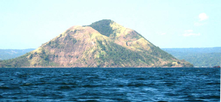
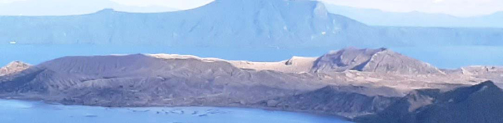
Today, one and a half years after that fateful day, the view of volcano from the 686-m high Tagaytay Ridge in Tagaytay City, is way different when it was years ago prior to the eruption as the island’s lush vegetation have all been killed or stripped of leaves, turning much of the island into a ghostly gray desert. However, some vegetation remains at the northern part. Even after the eruption, volcanic activity still continues. Last March 9 of this year, the volcano was placed under Alert Level 2 (increased unrest) and on July 1, at the time of this writing, it was raised to Alert Level 3 after a phreatomagmatic eruption.
Now that it’s back in the headlines, let’s get to know more about this volcano as well as its surrounding lake.
Although it’s grand viewpoint is in Tagaytay City in Cavite, the volcano and its lake are entirely located in the province of Batangas, with 10 towns (Agoncillo, Alitagtag, Balete, Cuenca, Laurel, Mataas na Kahoy, San Nicolas, Santa Teresita, Taal and Talisay) and two cities (Lipa and Tanauan) encircling the lake. The northern half of the island is under the jurisdiction of Talisay, the southern half to San Nicolas.
The volcano in most Taal Volcano postcards, the 311-m high Mount Binintiang Malaki (translated as “giant leg”), the northwest cinder cone which emerged overnight during the 1707 eruption, is actually old and dormant. It may seemingly look like an island, but Mount Binintiang Malaki is actually connected to the 16-sq-km , 8.8-km long Volcano Island. In fact, it is the island’s highest point. The aforementioned is also not the volcano’s only cone. In fact, there are 47 identified cones (26 tuff cones, 5 cinder cones and 4 maars), each a past eruption site.
Speaking of records, Taal Volcano is the lowest active volcano in the world (only the 180-m high, inactive Pali-Aike volcanic field in the Argentina-Chile border region is lower). It is also the second most active (out of 37 volcanoes, 21 of which are active) volcano in the country, after Mayon Volcano in Albay, with 41 recorded historical eruptions. The most notable eruptions are the violent, 7 month long eruption of 1754 (May 15 to December 12) and the American colonial period eruption of 1911 (January 27 to February 8) which killed 1,335 people.
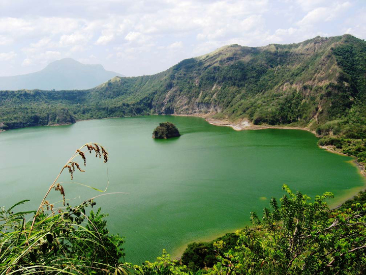
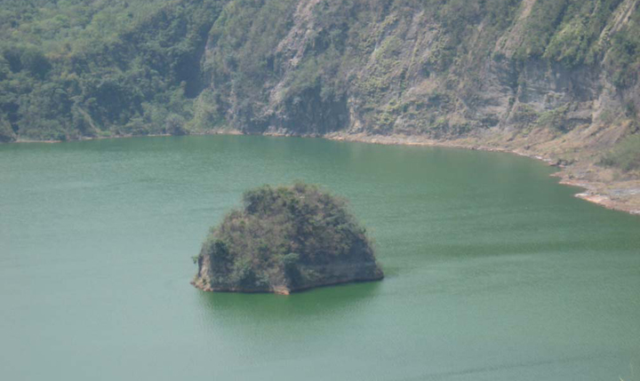
Most major eruptions, from 1749 to 1911, were from the Main Crater Lake, the largest lake on the island. The nearly 300-m high crater, with a diameter of about 2-kms, has a small rocky island called Vulcan Point. This setup was immortalized in “Ripley’s Believe It or Not” as an island (Vulcan Point) on a lake (Main Crater Lake) on an island (Volcano Island) on a lake (Taal Lake) on an island (Luzon Island). After the 2020 eruption, the Main Crater Lake mostly evaporated or drained but, after a series of typhoons, rainwater allowed the lake to fill up again.
The lake is formerly called Bonbon Lake. The present day Taal Lake itself is thought to be a remnant of a huge, 5,500- to 6,000-m high, perfectly formed, cone-shaped volcano that collapsed during a gigantic and violent eruption. Today, this big volcano is now considered by scientists to be dormant or extinct. Volcano Island, of course, is a different story.
For the record, it is the third largest lake (at 268-sq-kms) in the country (after the 949-sq- km Laguna de Bay and 340-sq-km Lake Lanao), with an irregular shoreline measuring about 23 by 16 kms. It is classified as a freshwater lake yet, before 1754, its waters were referred to by Spanish priests and historians as “salty.” The lake’s water salinity only ranges from 1/1000th to almost 1 percent (the ocean is 3 percent). The remains of dead coral and unusual marine life are found in Taal Lake in what you would normally find in the sea. How is all this possible?
The answer can be found in old maps that once showed Lake Taal as a bay connected to the West Philippine Sea by a wide, clear channel. Taal Volcano’s 1754 eruption may have blocked this channel with tephra, causing the waters to rise and, eventually, submerging the lakeside towns of Tanauan, Taal and Lipa, causing them to transfer to their present sites. It also trapped these marine creatures and forced them to adapt to a freshwater environment. Today, only a wide fissure at the southwest edge of the crater enables the lake to drain via the 10-km. long Pansipit River into Balayan Bay.
Today, the lake is home to marine anomalies such as the generally docile but poisonous Hydrophis semperi (one of five Hydrophis genus, it is one of only two freshwater sea snakes in the world); the tasty and very expensive, 1-m long maliputo or yellowfin jack (Caranx ignobilis); the 10-cm long, overharvested tawilis (Harengula tawilis, a lake delicacy, it is one of a few freshwater sardine species in the world); the archer fish and pipefish (Dunck-erkocampus dactiliophorus). Up until the 1930s, bull sharks (Carcharhinus leucas) once swam the lake’s waters until they became extinct, again through overfishing.
Image courtesy of Benjamin Locsin Layug